Hiking Trails form a network of paths that span across the Northeastern province of South Zagoria. Trails found within Chernarus follow the exact principles of the real life Czech Hiking Markers System[1], and each trail is accompanied with one of the four variants of colored trail markers seen throughout the landscape.
General
The Hiking trails found throughout Chernarus can be easily used to navigate the vast landscape of South Zagoria, with the addition of a topographic map stand located at resting spots at the end of each respected trail. The trails span 200 kilometers in total distance, with each trail being accompanied with four different colored markers, and a total of 93 directional crossroad signs throughout the entire province. Crossroad signs state the elevation above sea level in (meters), the distance in (kilometers), and are written in the Russian language (Cyrillic Script). Markers can be found on rocks, trees, and small wooden bollards dotted on the side of every trail. For some instances, trails can intersect through roads and towns, and are always followed by a light-thin brown trail distinguishable from the rest of the ground textures.[2]

Map stands found at every resting stop feature the second edition (2019) of the Chernarus tourist topographic map. The map scale ratio is 1:25000

The map legend features a World Factbook Map of Chernarus with the highlighted region of South Zagoria in red.
| Marker Color | Details |
|---|---|
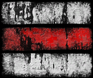 |
Red markers indicate the trail is the most difficult. |
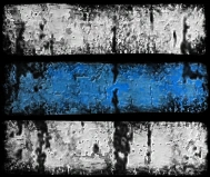 |
Blue markers indicate the trail is difficult. |
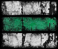 |
Green indicates the trail is easy and interconnects with other trails. |
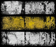 |
Yellow indicates the trail is easy and interconnects with other trails. |